My coffeeneuring exploits for 2015 felt low key relative to previous years. Not too much social interaction, only one beverage with high end latte art, and a couple of coffee purchases made at cyclocross races. Plus, there was a trip to a local park to test out my camping-stovetop espresso setup!

No. 1 was in Eugene, Oregon on Saturday the 3rd of October. Rode about a mile from my friends' home to
16 Tons Cafe (where they now use roasts from Eugene's own Wandering Goat Coffee, rather than Portland's Water Avenue Coffee). After a cappuccino and pastry, I continued to the U of O's Schnitzer Museum of Art, where tango friend Olga Volchkova's
beautiful iconography is currently being exhibited. I tacked on an additional 20-or-so miles out to Clearwater Park in Springfield and saw a songwriter/guitarist composing on a park bench overlooking the Middle Fork of the Willamette River.
After returning to my friends' home, I DJ'd a tango event that night. Total bike mileage for the day: 29.5

No. 2: Rode 3 miles from home on Saturday, October 10th to the
Cross Crusade cyclocross race at the
Alpenrose Dairy. Purchased a cup of joe from Nossa Familia Roasters, who had a tent set up with a huge French press. "Raced" (if you want to call it that) for about 9 miles (4 laps), then rode back home via West Coast Drinkery and New Seasons Market. Total mileage for the day: 16.6

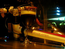
No. 3 (Sunday, October 25):
McCormick & Schmick's Restaurant and Bar is ridiculously close to my home (like 0.2 miles!), and that's where Bartender/friend Steve efficiently made me a tasty Spanish Coffee (that I took out to the patio in the rain to photograph with my Surly). I then extended this cofffeeneuring expedition by riding over to Kohl's afterwards (utilitaire style) to buy some bedding. Total mileage was the minimum 2.0!

No. 4 took place in Bend, OR on Saturday, October 31st. I rode a mile from my friend Joyce's home to the Deschutes Brewery facilities in Bend's Old Mill District, where
Cross Crusade Series (Race #4) was happening. It was a very challenging and windy course! Local roasters
Backporch Coffee Roasters had a tent sent up where they sold bags of beans. They included a free cup of coffee with my purchase.
Total mileage (including the race) was 13, about 4 of which I'll call 'coffeeneuring.'

No. 5 (Saturday, November 7): After 100+ kilometers of riding the
Verboort Populaire, I headed back into Forest Grove to forage for a coffee shop. I needn't have ridden into the center of town center, as
BJ's Coffee Company was fairly close to where most of us parked for the populaire (a couple miles from the finish). Ordered a mocha with whipped cream, as the barista thought that would look more photogenic than his attempt at latte art. Coffeeneuring portion of this drizzly day was about 6 miles.

No. 6 (Sunday, November 8): This is how I used to coffeeneur, all the time ... go to a high end coffee house near the center of Portland, enjoy an espresso beverage with great latte art, then head on to my weekly tango practica. The establishment I chose on this occasion was
Coffeehouse Northwest where I consumed part of the novel "Birdsong" by Sebastian Faulks along with a beautiful latte. Put my bike on the Max (light rail) for portions of the day's journey, but still pedaled 7.4 miles.

No. 7 (Saturday, November 14): Something new in my coffee world ... stovetop espresso with a backpacking-sized camping stove. I've had the stovetop unit forever, but had to go out and purchase the burner and fuel earlier in the week. The ride out to Beaverton's Center Street Park was a little under 2 miles, and once set up, the espresso-making process worked okay. Because of the wind, heating the water to a boil took a lot longer than the trial run at home. But the mission (complete with a drinkable beverage) was accomplished! Mileage: 3.7.

And that's it for this year's coffeeneuring challenge. There were moments when I didn't think I'd get it done. But between incorporating a couple cyclocross races, (plus a trip to the bar down the street), I think this year's version is now complete!
This photoset is also
here on Flickr!
 No. 1 was in Eugene, Oregon on Saturday the 3rd of October. Rode about a mile from my friends' home to 16 Tons Cafe (where they now use roasts from Eugene's own Wandering Goat Coffee, rather than Portland's Water Avenue Coffee). After a cappuccino and pastry, I continued to the U of O's Schnitzer Museum of Art, where tango friend Olga Volchkova's beautiful iconography is currently being exhibited. I tacked on an additional 20-or-so miles out to Clearwater Park in Springfield and saw a songwriter/guitarist composing on a park bench overlooking the Middle Fork of the Willamette River.

 No. 2: Rode 3 miles from home on Saturday, October 10th to the Cross Crusade cyclocross race at the Alpenrose Dairy. Purchased a cup of joe from Nossa Familia Roasters, who had a tent set up with a huge French press. "Raced" (if you want to call it that) for about 9 miles (4 laps), then rode back home via West Coast Drinkery and New Seasons Market. Total mileage for the day: 16.6
 No. 3 (Sunday, October 25): McCormick & Schmick's Restaurant and Bar is ridiculously close to my home (like 0.2 miles!), and that's where Bartender/friend Steve efficiently made me a tasty Spanish Coffee (that I took out to the patio in the rain to photograph with my Surly). I then extended this cofffeeneuring expedition by riding over to Kohl's afterwards (utilitaire style) to buy some bedding. Total mileage was the minimum 2.0!
 No. 4 took place in Bend, OR on Saturday, October 31st. I rode a mile from my friend Joyce's home to the Deschutes Brewery facilities in Bend's Old Mill District, where Cross Crusade Series (Race #4) was happening. It was a very challenging and windy course! Local roasters Backporch Coffee Roasters had a tent sent up where they sold bags of beans. They included a free cup of coffee with my purchase.

 No. 5 (Saturday, November 7): After 100+ kilometers of riding the Verboort Populaire, I headed back into Forest Grove to forage for a coffee shop. I needn't have ridden into the center of town center, as BJ's Coffee Company was fairly close to where most of us parked for the populaire (a couple miles from the finish). Ordered a mocha with whipped cream, as the barista thought that would look more photogenic than his attempt at latte art. Coffeeneuring portion of this drizzly day was about 6 miles.
  No. 6 (Sunday, November 8): This is how I used to coffeeneur, all the time ... go to a high end coffee house near the center of Portland, enjoy an espresso beverage with great latte art, then head on to my weekly tango practica. The establishment I chose on this occasion was Coffeehouse Northwest where I consumed part of the novel "Birdsong" by Sebastian Faulks along with a beautiful latte. Put my bike on the Max (light rail) for portions of the day's journey, but still pedaled 7.4 miles.
  No. 7 (Saturday, November 14): Something new in my coffee world ... stovetop espresso with a backpacking-sized camping stove. I've had the stovetop unit forever, but had to go out and purchase the burner and fuel earlier in the week. The ride out to Beaverton's Center Street Park was a little under 2 miles, and once set up, the espresso-making process worked okay. Because of the wind, heating the water to a boil took a lot longer than the trial run at home. But the mission (complete with a drinkable beverage) was accomplished! Mileage: 3.7.
 And that's it for this year's coffeeneuring challenge. There were moments when I didn't think I'd get it done. But between incorporating a couple cyclocross races, (plus a trip to the bar down the street), I think this year's version is now complete!
This photoset is also here on Flickr!
And that's it for this year's coffeeneuring challenge. There were moments when I didn't think I'd get it done. But between incorporating a couple cyclocross races, (plus a trip to the bar down the street), I think this year's version is now complete!
This photoset is also here on Flickr!