
*SR = super randonneur
I’m getting kinda known for my late starts at randonneuring events. (Lord knows I can ill afford them.) But for the Alsea Falls 400k, I was totally on track to arrive ½ hour early. Got some coffee in Newberg ‘round 5:00 AM, approached McMinnville about 5:30, went all the way through town (so I thought), but saw no Best Western, and nothing resembling the address “2035 S Highway 99W.” I made two more passes from the eastern edge of town to the western end of the one-way streets, the first time consulting a gal at McDonalds, and the second time a gal at Dutch Brothers. It never occurred to me, even when viewing Google Maps the night before, that there was anything to McMinnville beyond the one-way streets. But the gal at Dutch Brothers had an iPhone with a map function and let me know I hadn’t gone nearly far enough.
I finally got to the Best Western at 6:10 AM, and even though I had laid everything out and deliberately packed the night before, I discovered my pannier neglected to make the trip. Unplanned lateness plus a missing critical piece of equipment turned me into a less-that-fully-functioning basket case. I couldn’t even unbuckle my bike shoes! Michael and Philippe were patient, the latter loaning me some old leather toe straps to secure my improvised duffle bag to the rear rack. Michael called out my actual departure time as 6:33 when I left.
According to Michael, the first part of the ride (up to Bald Mountain) would be the hilly part,
The roads from Willamia to Sheridan and Ballston were familiar from other brevets, but Broadmead Rd. linking Ballston to Perrydale Rd. was new to me. Perrydale Rd. essentially runs into Dallas, where I stopped at Santaim Cycles for a tire pump, as mine was in the pannier that got left at home. Salesman Dan was quite intrigued with my Stumptown (he seemed to know the guy that designed it for Mountain Cycle), and with my generator light setup. I guess not too many randonneuring types frequent that establishment.
Falls City struck me as a town hard hit by the economy. Or maybe it was already hard hit before the downturn. I dunno. The ladies behind the counter let me know that the previous rider been through about ½ hour earlier. So I wasn’t gaining time on anyone.
What would a Philippe/Michael brevet be without a gravel section? Well, the one between Falls City and Kings Valley Road was fairly tame as gravel roads go … quite hard-packed. ‘Twasn’t necessary to deflate the tires.
Seemed like there was an inordinate amount of roadkill on this ride. Quite a few deer … running the gamut from freshly extinguished to thoroughly decayed skeletons. There were rodents, felines, and even a colorful bird that had met untimely roadside demises. Made me wonder if Polk Country has any sort of clean-up program for deceased roadside animals.
One of the prettiest roads of the day was the Alsea Highway. It’s funny how “pretty” and “steep” often go hand-in-hand on a ride like this. An unfortunate part of that 16-mile ascent was all the litter along the side of the road (quite noticeable at my slow uphill pace). The main culprits appeared to be consumers of Dutch Brothers Coffee and Corbett Canyon wines. (Corbett’s 1.5 liter bottles have a distinctive shape.) I got to thinking that this is probably a result of a large portion of society that says (from the top down) “it’s okay to do whatever, as long as you’re not caught.”
Shadows got real long riding from Alsea to Alsea Falls, and by the time I descended down to Monroe, it was totally dark. I couldn’t find West Ingram Island Road out of Monroe until after I rode up the down the main drag a few times and then got help from a Dari Mart employee. Then before Harrisburg I failed to see McMullen Lane, even after a local kid in a driveway told me “it’s right up there by the stop sign.” Never saw a stop sign till a mile or so further when I got to Highway 99E. Chalk up another bonus mile or two.
It was good to see cheery Keith and Alex signing cards and offering refreshments in Brownsville (a town I’d never been to before). At that contrôle, I topped off my Coke-filled water bottle with more Coke, and my water-filled water bottle with more water. But it was the can of V-8 that was most refreshing there at 12:30 in the morning. And then it was time for the Kohans to finally close up shop and head back home to Salem.
I too was headed to Salem … via Jefferson … then some challenging hills along Parrish Gap Road (I actually ended up walking one of those hills) … then Turner. Lo and behold, guess who appeared in Turner? Marcello! Turns out he did this ride on significantly less sleep than my insufficient amount, and chose Turner (about 8 miles shy of Salem) as a napping place. We ended up riding the last 35 or so miles back into McMinnville together.
It got light shortly after leaving Salem. Again, there were more rollers through the Eola Hills (premium pinot noir country) as we foraged our way back to McMinnville. And then a funny thing happened as we were minutes from the end (according to our cue sheets and computers). We missed a turn! All of a sudden we found ourselves in downtown McMinnville asking directions to the Best Western. Add another 30 minutes to our times. It was déjà vu all over again. The Best Western and I were not on the same plane of consciousness this weekend. Might has well been on different planets!
But when Marcello and I finally got there, Philippe greeted us and checked us in. Marcello then elected to drive straight home, while I took a bath and a half hour nap before heading back to Portland (where a tango lesson, class, and practica awaited). My official time was 26:30, but my actual riding time was at least a couple hours less.
Thanks to Michael and Philippe for an excellent, challenging route. And also for putting up with such a basket case!
Photos are here on Flickr.
6 comments:
Nice write up, glad you enjoyed the ride. I would just like to note that I *never* said that it was one big climb, and the rest of it was flat. Some other folks did, but not me. I think they just looked at the elevation profile, which is deceptive because the first climb gets you to a much greater elevation than anything else in the ride that it flattens out all the rollers (whose cumulative effect is substantial.)
You can look at both the ride information page (which I wrote) and my pre-ride notes, and I am very upfront about the fact that you start with a big hill, and then you have 200' rollers to Alsea Highway (although I think that last one to get out of Kings Valley was bigger), and then a couple big climbs into and out of Alsea. In my pre-ride notes, after I'd ridden the course, I even tried not to diminish the effort it took to go through Brownsville and Parrish Gaps, as they're pretty steep, if short.
So it was the V8 in Brownsville that did the trick. I would have thought it would be the half can of Red Bull you drank that would spur you on to the finish. I remember you were in amazingly good spirits and seemed ready to tackle the rest of the ride. Glad we were of assistance and happy to have done it. Manning the control into the wee hours was fun.
Hey Michael ... you're right ... and I really don't know where I got the impression of relative flatness. Maybe it's related to my erroneous belief that McMinnville ended before Linfield College. I re-looked at the map tonight, and realized my whole sense of direction was skewed 90 degrees last Saturday and Sunday mornings. But I generally don't do thorough research before brevets. I was committed to the 400k regardless of terrain. You always organize fresh, interesting rides and I appreciate that.
Interesting that you know what kind of wine bottles were decorating the side of the road. Someone is drinking a lot of vino on that road! Can't think of a more littered roadside. I was also surprised at the hills in and out of Alsea. Should have known from the elevation profile but the 1200 ft climbs failed to register with my pea brain compared to the first 2500 ft climb. I walked a few hills too. It felt good.
Michael doth protest too much :-)
Great write-up, Bill (as usual)! Now get yourself a GPS (just make sure it's securely fastened to your bike . . . )
Hey now, Cecil. I'm fine with having a reputation for designing hilly courses. I'm not fine with having a reputation for misleading people about them.
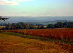
Bill, that picture that you took from Westside Road is really outstanding.
Post a Comment